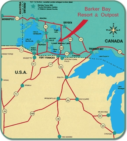
Barker Bay Resort - Located on Lower Manitou
Links Tips Link Photos Link Location Link Contact Link Rates Link Winter Link Hunting Link Lodging Link Fishing Link Home Link


How to get here

location 2009
After crossing the bridge into Canada at International Falls, take Highway 11 east for 20 miles, turn left onto highway 502 and go 25 miles, turn left at the Cedar Narrows Road (gravel) and go 29 KM, turn left at the Esox Landing sign and go approximately 1 mile to the Esox Lake landing. 
When boating in, the ride will be approx. 18 miles. Some helpful maps are: the 1:50,000 Canadian Topographic System maps.  Map 52 F/3 will detail out the boat-in area of Esox Lake and the Manitou Stretch which leads to the Lower Manitou and Barker Bay.  Map 52 F/7 details most of the Lower Manitou, the Manitou Straits and the Upper Manitou.  Maps may be available at Rainy Lake Sports in Fort Frances and at the "Great Bear" convenience store 12 miles east of Fort Frances on Highway 11.  

Click "Here" to view large lake map.

GPS Coordinates to remember
North 49 degrees 16.132...West 93 degrees 02.913 - Our Dock at Barker Bay
North 49 degrees 05.673...West 93 degrees 16.297 - Rock Hazard in Esox Lake
North 49 degrees 07.352...West 93 degrees 15.454 - Rocky Channel from Esox Lake into the Manitou Stretch

Barker Bay Outposts - How to get here


Manitou sunrise
Manitou Moon rise

I Fishing I Lodging I Rates I Winter I Hunting I Contact Us I Location I Photos I Home I

Email : info@barkerbay.com

All Images ©2010 Barker Bay Outposts